GROUNDWATER
Michigan is fortunate in that most parts of the state have sufficient supplies of
water that can be reached by digging wells into the surface layers of glacial material or
down into the rock layers that act as aquifers--water bearers–to meet our immediate
needs. Water received in the form of rainfall or snowfall either flows off, evaporates, or
seeps down into the surface soil and loose material and further into the bedrock below.
Porous rock layers such as sandstone and limestone allow some water to collect in the
spaces (pores) between the sand grains or particles that make up the rock layer, and this
water may flow through these porous rock layers for a considerable distance. The
sedimentary rock aquifers are good storage areas that can be drilled for domestic and
industrial water supplies. Because the sandstone and porous limestone layers of Michigan
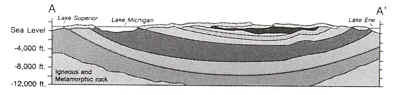
are in a saucerlike basin (i.e., the Michigan Basin), most of
the Lower Peninsula does have the potential for springs and artesian, or naturally
flowing, wells. As the demand on this water stored underneath the earth’s surface
increases because of population and industrial pressure, water’s natural tendency to
flow decreases, and the water must be pumped to the surface.
Most communities in the state get their municipal water from wells, and
as the need increases, the wells often have to be dug deeper and larger to supply the
greater amount of water. There is a problem of pollution as sewage and toxic, or
poisonous, materials can get into the rock formations that supply freshwater, and another
major problem is that the water supply can be depleted as a result of heavy withdrawals
made by a city, industry, and wells dug by property owners. Such depletion is especially
troublesome during summer dry spells as an aquifer may actually go dry.
Most urban communities in the state have a common source of water. The
water is pumped into a storage tank (a "water tower") 15 to 20 m above the
ground, to provide pressure, and is distributed through pipes to homes throughout the
community. The groundwater supply, especially that in the bedrock, is badly depleted along
Lake Michigan between Muskegon and Petoskey and from the southern state line to the thumb
area in southeastern Michigan. Portions of the Upper Peninsula have both quality and
quantity problems, especially the igneous rock areas of the western Upper Peninsula. Salt
layers in the rock also mean that salt can sometimes get into the water supply in certain
regions like Detroit, Midland, and Montague-Whitehall area north of Muskegon.
Michigan is fortunate in that it generally has abundant underground
water resources. Added to these sources is the tremendous supply that Lakes Superior,
Michigan, Huron, and Erie represent.

Source: L.M. Sommers, Michigan: A Geography (1984).
CROSS-SECTION (below)
Source: L.M. Sommers, Michigan: A Geography (1984).
Groundwater is important to the Great Lakes ecosystem because it provides a reservoir for
storing water and slowly replenishing the lakes in the form of base flow in the
tributaries. It is also a source of drinking water for many communities in the
Great Lakes basin. Shallow groundwater also provides moisture to plants.
As water passes through subsurface areas, some substances are filtered
out, but some materials in the soils become dissolved or suspended in the water. Salts and
minerals in the soil and bedrock are the source of what is referred to as 'hard'
water, a common feature of well water in the lower Great Lakes basin.
Groundwater can also pick up materials of human origin that have been
buried in dumps and landfill sites. Groundwater
contamination problems can occur in both urban-industrial and agricultural areas.
Protection and inspection of groundwater is
essential to protect the quality of the entire water supply consumed by basin populations,
because the underground movement
of water is believed to be a major pathway for the transport of pollution to the Great
Lakes. Groundwater may discharge
directly to the lakes or indirectly as base flow to the tributaries.
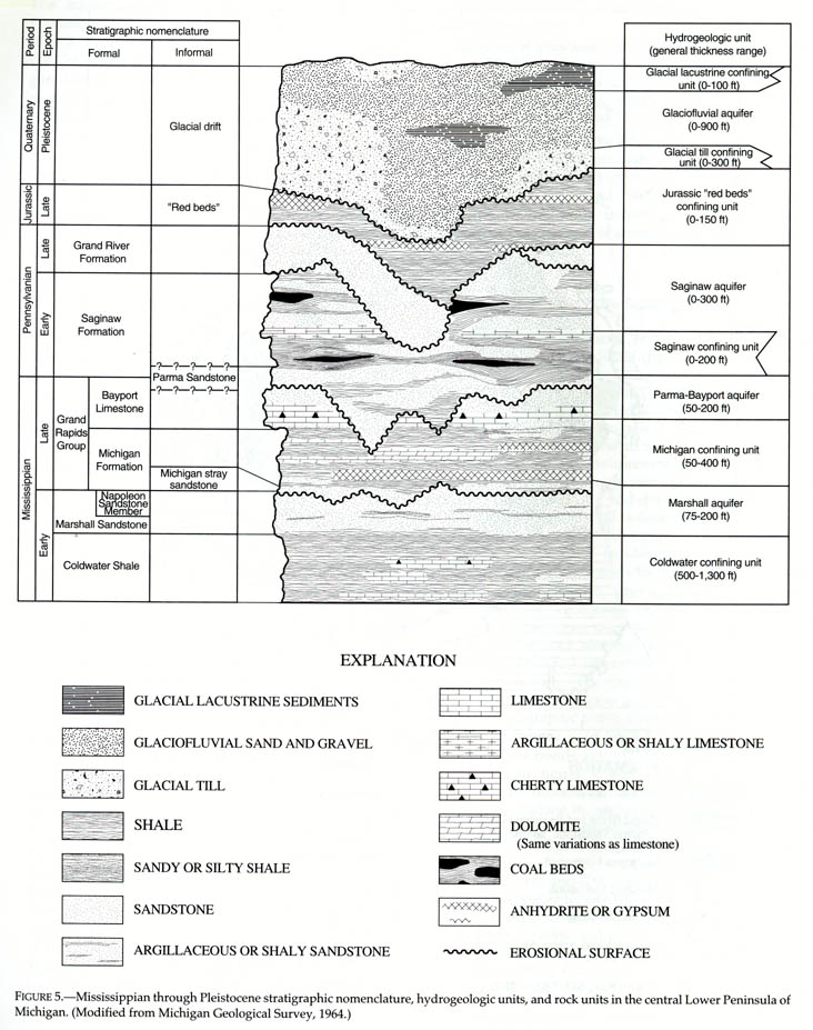
Above and within the Coldwater shales is one of the most interesting of our
rock strata-the Marshall sandstone.
Source: L.M. Sommers, Michigan: A Geography (1984).
The rim of the Marshall comes to, or is near, the surface in many places from the tip of
the Thumb where it is carved to interesting scenery, through Huron, Jackson, Calhoun, and
Ottawa counties. In the early day many quarries were opened in it and the sandstone used
for building purposes. One of our ghost towns is Grindstone City, Huron County, where once
a flourishing industry produced the largest and finest grindstones, scythestones, and
honestones in the world. Artificial carborundum, however, killed that industry. But when
particularly fine grind-and hone-stones were needed the quarry was occasionally operated.
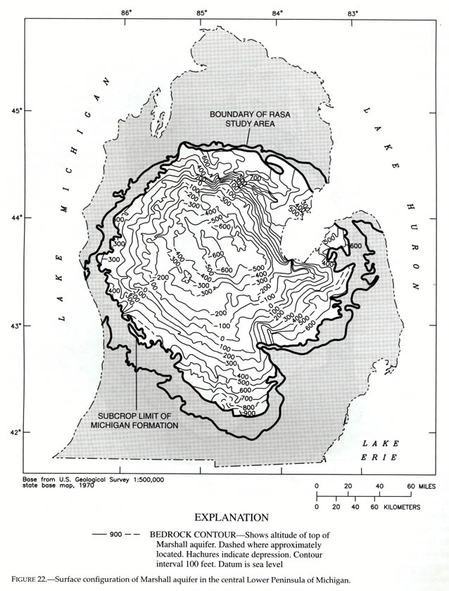
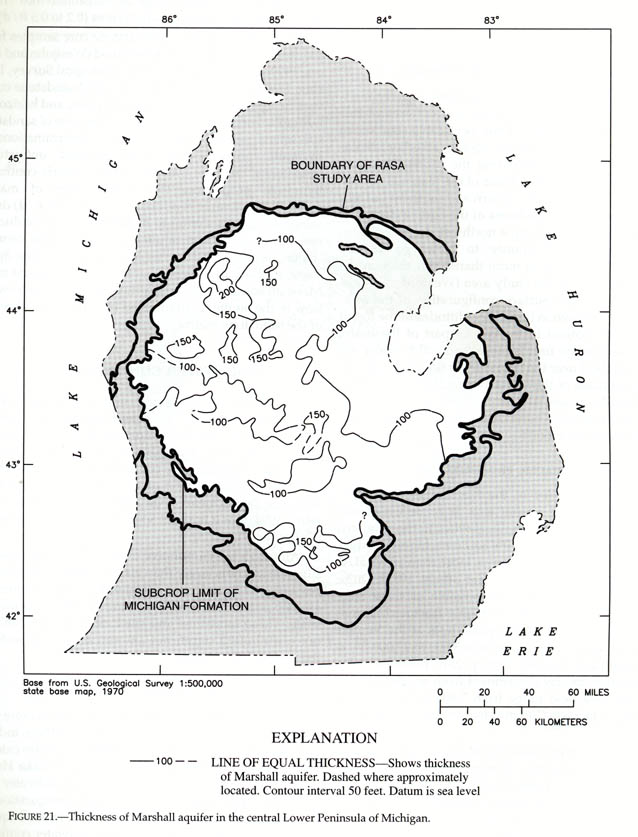
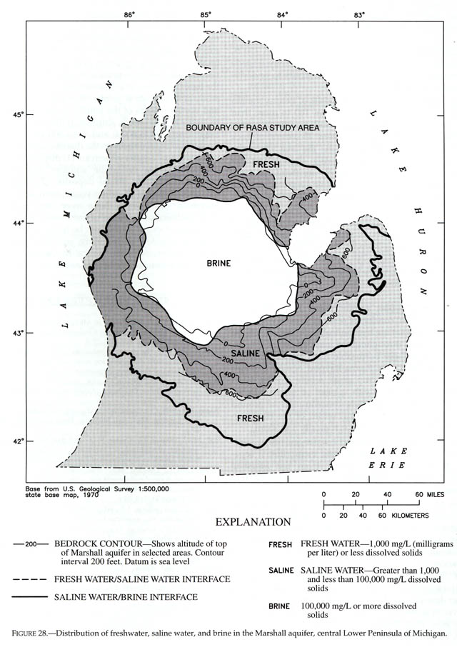
Near its buried edges the Marshall sandstone is a major groundwater
aquifer and is the source of the water supply for many cities. The map below shows the
altitide above or below sea level (in feet) of the top of the Marshall sandstone.
Again note that, as in all of the major bedrock units of the Michigan
Basin, the Marshall is buried deepest in the center of the basin.
Source: L.M. Sommers, Michigan: A Geography (1984).
Deeper, toward the center of the basin, the groundwater in the Marshall gradually seep
down the slopes toward the center of the basin (see below).
Source: L.M. Sommers, Michigan: A Geography (1984).
Source: L.M. Sommers, Michigan: A Geography (1984).
Along the way it dissolves mineral matter in the rock and when it reaches the bottom of
the bowl (Midland County) and meets the old sea water of Mississippian time imprisoned
there, it is a very bitter water carrying much chlorine, iodine, magnesium, sodium, and
other salts and minerals in solution.
Source: L.M. Sommers, Michigan: A Geography (1984).
This brine is the source material for a great chemical industry–Dow
Chemical, among others.
Source: L.M. Sommers, Michigan: A Geography (1984).
(The map key is the same for both maps)
Source: L.M. Sommers, Michigan: A Geography (1984).
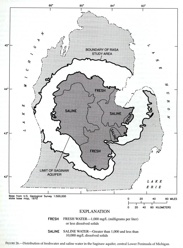
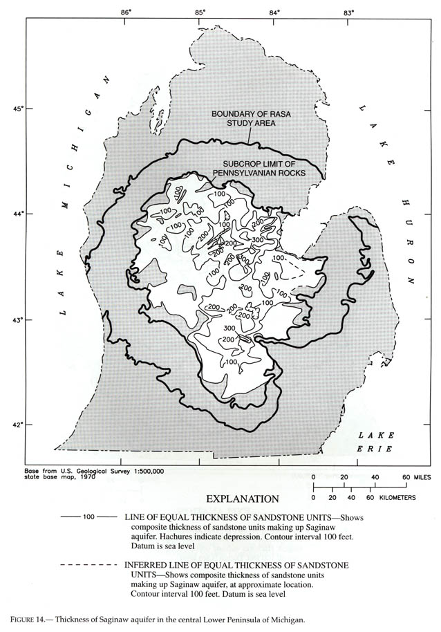
The Saginaw Aquifer
One of the major bedrock aquifers in centeral and southern Michigan is the Saginaw
sandstone. The map below illustrates that this aquifer is, in places, also saline.
Source: L.M. Sommers, Michigan: A Geography (1984).
The Saginaw sandstone is 100-200 feet thick in most places (see below)
Source: L.M. Sommers, Michigan: A Geography (1984).
Parts of the text on this page have been modified from L.M. Sommers' book entitled, "Michigan: A Geography", and from the NOAA Publication, "The Great Lakes An Environmental Atlas and Resource Book" (1995).
This material has been compiled for educational use only, and
may not be reproduced without permission. One copy may be printed for personal
use. Please contact Randall Schaetzl (soils@msu.edu)
for more information or permissions.