Historical timeline of early Detroit
1701-Fort Pontchartrain is established
1760-French secede Fort Detroit to British
1796-Fort Detroit becomes American
1803-Incorporated as town and first post office
1815-Incorporated as city and Territorial Capital
1837-Michigan admitted to Union
Fort Detroit in 1763, from Bellin's Atlas of 1764
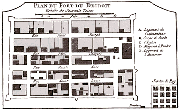
Fort Pontchartrain was built on the Detroit River, under the direction of Antoine de
Lamothe Cadillac, in 1701. Soldiers, carpenters and a dozen or so Indians labored in the
summer sun that year to get the tiny church of St. Anne under a roof, and a little over an
acre of land enclosed in a garrison. It would be one of a string of forts built along the
Great Lakes dotting either side of Lake Ontario and Lake Erie. The purpose: to provide
French fur-trading depots. A place where Indians and coureurs de bois could bring their
pelts, to be traded for a musket, a knife, a sack of flour, or far too often, a jug of
brandy. Eventually, these furs were shipped to France to be made into hats or other
clothing for people the well-to-do.
Fort Detroit was originally built by the French in 1701. It was built along the Detroit
River at the gateway from Lake Erie to the western Great Lakes. The French called it Fort
Pontchartrain. It was a small town surrounded by a stockade wall. It became the modern
city of Detroit, Michigan.
The French surrendered the fort to the British in 1760 and the British changed the name to
Fort Detroit. The British made the fort even stronger. Fort Detroit was attacked by
Indians during Pontiac’s War in 1763, but the Indians never overcame the strong
defenses. The British used Fort Detroit as a base to plan and launch Indian raids into the
Ohio Valley. Fort Detroit became an American fort in 1796.
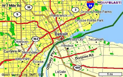
Source: Mapquest
Detroit was relatively easy to build on, except that it was quite wet and swampy, which did pose sompe problems. But, it had fairly few moraines, and because of this, the land in Detroit was very flat. Also, it had very easy access to the Great Lakes, because it was right on one. You can tell this in almost any picture of Detroit, because there are never hills in the pictures of Detroit. Below is a sample of some early photos form Detroit when it became more industrial.
It’s pretty easy to see how flat the land was in Detroit. There are very few hills, and it has a large waterfront.
This page was constructed by a former GEO 333 student, Daniel Sterling.
This material has been compiled for educational use only, and may not be reproduced without permission. One copy may be printed for personal use. Please contact Randall Schaetzl (soils@msu.edu) for more information or permissions.