GLACIAL LAKES IN MICHIGAN
It is generally accepted that the
Great Lakes did not exist in preglacial times but are the cumulative
result of several phases of glaciation that took place during the last 1.5
million years (the Quaternary Period). It is also believed that some sort
of system of large lakes existed in conjunction with the earlier glacial
and interglacial episodes, but the character and configuration of the
present Great Lakes are the products of the final deglaciation of their
drainage basin that began around 14,800 years before the present (14,800
BP). At that time several major ice lobes
characterized the margin of the continental glacier within the Great Lakes
area. These included, from west to east, the Superior (1), Chippewa (2),
Green Bay (3), Michigan (4), Saginaw (5), and Huron-Erie (6) lobes. As the
margins of these lobes retreated, glacial meltwater and precipitation
drained southward to the Gulf of Mexico because higher land or glacial ice
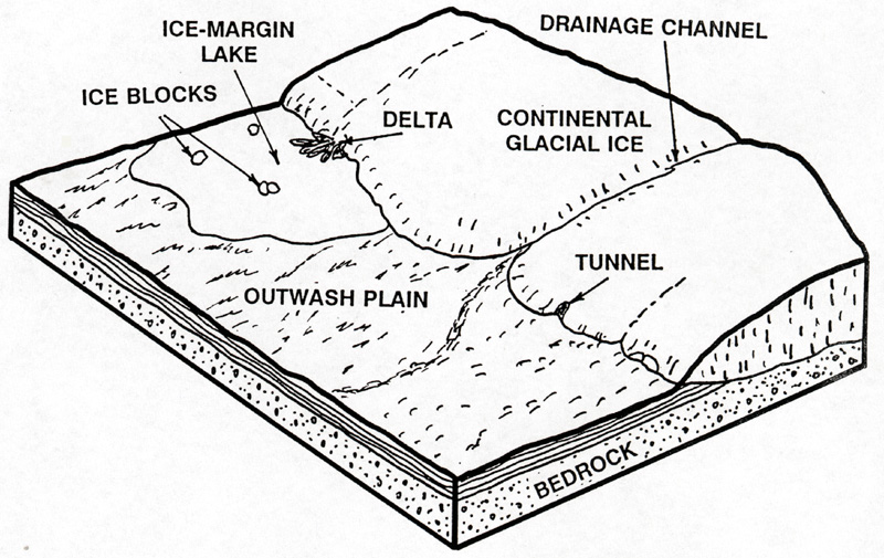
blocked flow in other directions. Ice-marginal lakes (or proglacial lakes)
form when the land in front of the ice margin slopes toward the
ice, allowing meltwater to pond directly in contact with the ice, as
shown below.
Source: Unknown
One interesting landscape in our state includes the broad expanse
of level lands from the Ohio boundary around "the Thumb", in the Saginaw
Basin bounding lakes Erie, St. Clair, and Huron, scattered flat lands
bordering Lake Michigan, the flat plains of the Ontonagon valley, and the
marshy lowland of the watershed of the Tahquamenon and Manistique rivers.
Long ridges of sandy gravel interrupt what would otherwise be great
expanses of flat land. Many sand dunes occur along their inland slopes far
from any body of water. As we cross the level lands we find they are
actually terraces leading down to the Great Lakes, each terrace separated
from its neighbor by a high or low steep cliff. These lands have areas of
heavy clay interspersed with stretches of water-washed sand and gravel.
They were once lake beds; the ridges of gravel were beaches; the flat
stratified sand and gravel plains and clay plains with a veneer of sand or
gravel were fillings of old bays of ancient long-departed lakes and the
deltas of rivers flowing into them. Each of these glacial lakes had a
name. The level plain from Seney to Shingleton, Schoolcraft County, was
the bed of Lake Algonquin. The swamps of the UP are the remnants of that
lake.
As of 14,800 year ago (see map below), when
the retreating ice margins were well to the south of Lansing, the land
sloped away from the ice, and thus water was not ponded in front
of it. Instead, meltwater streams formed, washing sediment out, away
from the ice. Sand and gravel, which these streams could not carry,
was laid down as outwash, in broad, flat outwash plains (see the diagram
above).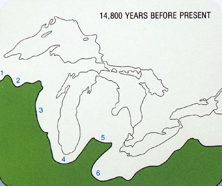
Source: Atlas of Michigan, ed. Lawrence M. Sommers, 1977.
By 14,000 BP (below) a considerable part of the lower Peninsula had been deglaciated, and the three lobes affecting the area were more clearly separated. Drainage continued southward to the Gulf of Mexico.
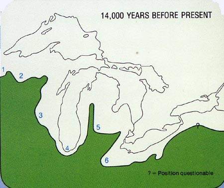
Source: Atlas of Michigan, ed. Lawrence M. Sommers, 1977.
Further retreat of the margins of the Michigan and Huron-Erie lobes resulted in the impoundment of water between the ice margin and moraines (the tops of which were at higher elevations than was the ice margin) formed previously by the glaciers. Thus, a series of lakes came into existence, one side of which lay against the ice margin; these sort of lakes are called proglacial lakes. This is the first phase of the complex development of the present Great Lakes, which are the result of such factors as erosion and deposition by the glaciers, blockage of drainage by glacial ice, subsidence of the land beneath the glacier's immense weight, followed by rebounding of land during and after glaciation, and postglacial lowering of the lake outlets by erosion. The following stages summarized some important aspects of the further development of the lakes. The first proglacial lakes to form were Maumee (M) and Chicago (C), associated with the Huron-Erie and Michigan lobes, respectively. Initially, excess water from Glacial Lake Maumee flowed southwest to the Wabash River, and Glacial Lake Chicago drained west and south by way of the Chicago and Illinois Rivers (P). Further retreat of the ice margin resulted in the formation of Glacial Lake Saginaw (S) in the Saginaw lowlands, by about 13,800 BP. This lake drained westward through the Maple River - Grand River (G) lowland, and hence into Glacial Lake Chicago. The recession of the ice margin in southeast Michigan also uncovered lower north-flowing outlets for Glacial Lake Maumee. One of these, referred to as the Imlay City Outlet (I) after the city of the same name, permitted water to drain from Lake Maumee northward into Lake Saginaw. Today, a deep channel, the Imlay City channel, can still be seen to the east of town, as a reminder of the water it once carried toward Glacial Lake Saginaw.
At this time, about 1/2 of the lower Peninsula was deglaciated, but ice still covered all of the Upper Peninsula.
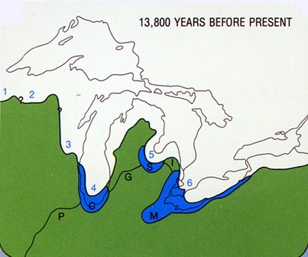
Source: Atlas of Michigan, ed. Lawrence M. Sommers, 1977.
About 12,500 BP (see below) another lower drainage way referred to as the Ubly Outlet (U) was uncovered in southeast Michigan by the retreating ice margin. This outlet carried water northward from the Erie basin. The resultant lake in the Erie basin was named Glacial Lake Whittlesey (W), which had a lower level than its predecessor, Maumee. Water flowing through the Ubly outlet drained into Glacial Lake Saginaw, which had increased in size because of retreat by the Saginaw lobe ice. Excess waters of this glacial lake continued to drain westward to Glacial Lake Chicago by way of the Maple River-Grand River lowland. Glacial Lake Chicago continued to drain southward, but its level and that of Lake Saginaw were somewhat lower because of downcutting and erosion by their outlet streams.
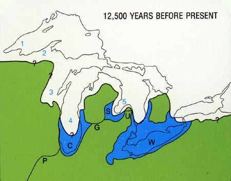
Source: Atlas of Michigan, ed. Lawrence M. Sommers, 1977.
By 11,000 BP (below), most, if not all, of the basins of Lakes Michigan and Huron were deglaciated, and one large body of water, Lake Algonquin (A), resulted from the coalescence of Glacial Lakes Saginaw and Chicago. This lake was more extensive than the present Lakes Michigan and Huron (582 ft or 175 m above sea level) because its altitude was more than 20 feet higher (605 ft or 182 m). Drainage out of Lake Algonquin changed with time from the previously established Glacial Lake Chicago outlet (P) to the Lake Erie Basin by way of the St. Clair-Detroit River (SD), and eventually by even lower outlets across what is now Ontario. Water in the Erie basin (E) drained eastward over an ancestral Niagara Falls into Glacial Lake Iroquois (I), which discharged into the Hudson River of New York by way of the Rome outlet (R). The predecessor to Lake Superior, Glacial Lake Duluth (D), formed at this time and drained southward by way of the St. Croix River (SC).
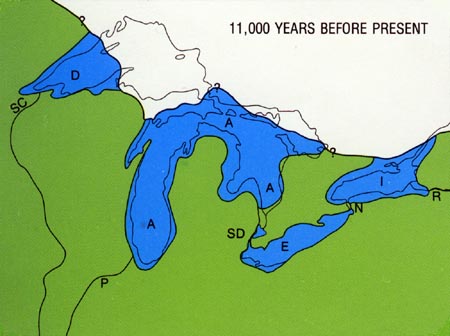
Source: Atlas of Michigan, ed. Lawrence M. Sommers, 1977.
Final deglaciation of the state took place about 9,500 BP, and permitted Glacial Lake Duluth to grow in area and at the same time drain by lower outlets, first southward across the central UP, and later eastward via the St. Marys River. The retreat of the ice from land, which had been depressed by the former weight of the glacier, permitted unusual low-water lake levels in both the Michigan (Glacial Lake Chippewa-CP) and Huron (Glacial Lake Stanley-ST) basins. This was accomplished by the presence of such low-level drainage ways across Ontario as the Ottawa River (O), which drained into the Champlain Sea (CS), an estuary of the Atlantic Ocean. Lake Erie continued to drain eastward via Niagara Falls (N), which were slowly retreating because of erosion. The present-day Great Lakes formed as the earth’s crust, depressed from the weight of the ice sheets, rebounded after deglaciation. This raised the level of the Ottawa River outlet, drained the Champlain Sea, formed the St. Lawrence River, and eventually reestablished the St. Clair-Detroit River outlet for Lake Huron.
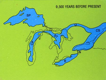
Source: Atlas of Michigan, ed. Lawrence M. Sommers, 1977.
For a summary of the later stages of lake evolution, see the image
below: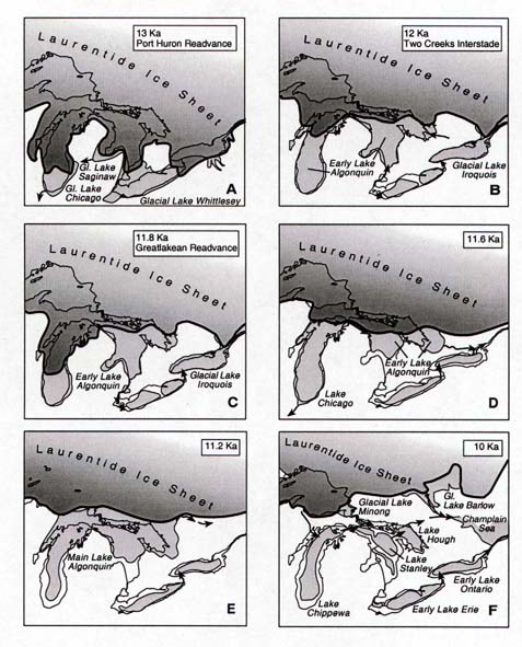
Source: Michigan State University, Department of
Geography
Each lake had
an inlet and an outlet. Often one lake drained into another, which
then drained into another, etc. The map below shows the major
outlets and inlets of the proglacial and post-glacial lakes in the Great
Lakes region. Not all outlets were in use at the same time.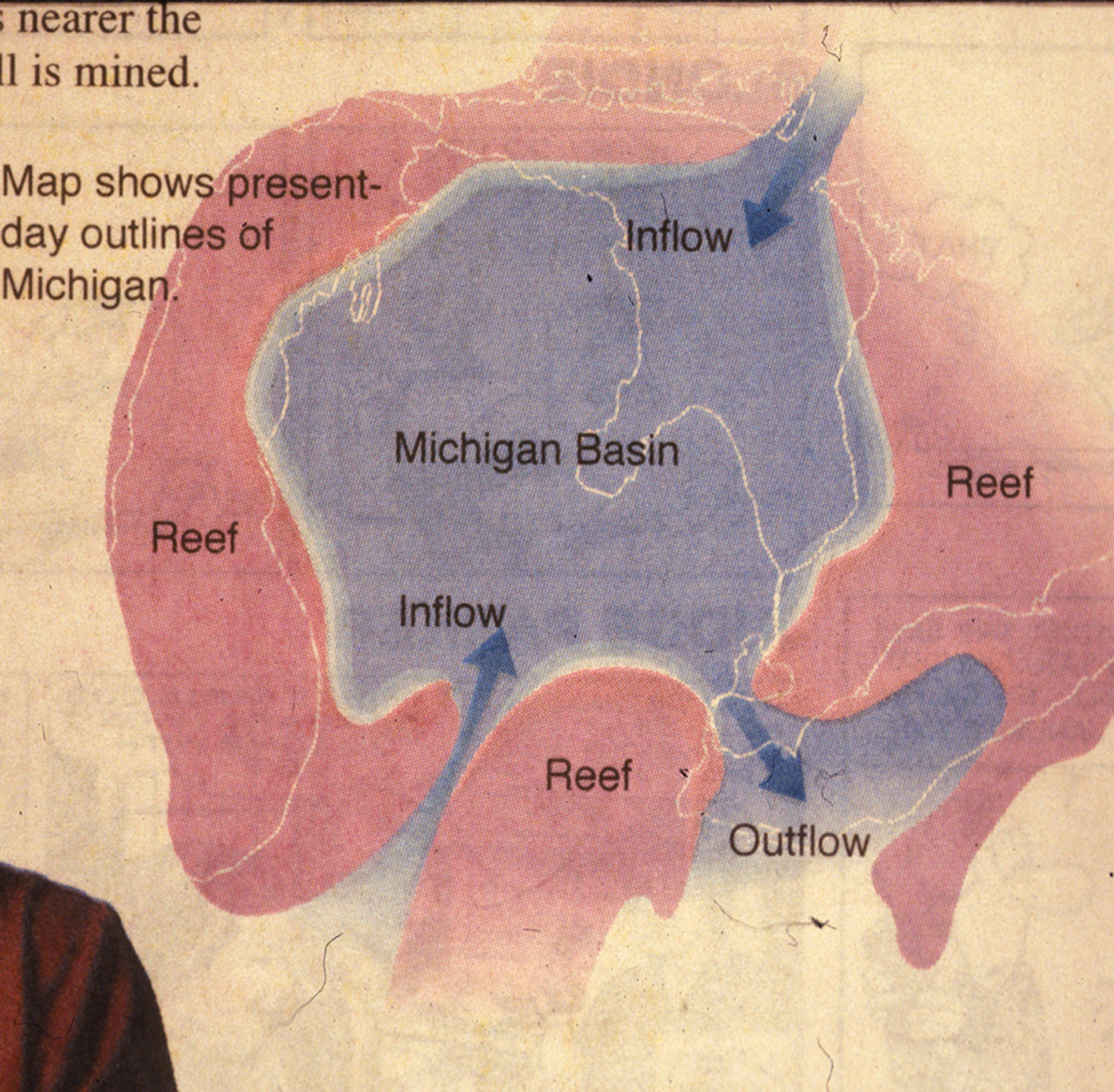
Source: Detroit News
Lake levels
The paleo Great Lakes underwent a
series of stages, or levels. These stages occurred because (1) the
crust was rebounding (rising) as the weight of the ice was slowly being
removed, (2) the retreating ice sheet was uncovering lower and lower
outlets for the lakes, and (3) the outlets themselves were being cut down
by the water leaving the lakes. Thus, the lakes underwent high
stages, and low stages. These stages are summarized below for Lakes
Huron and Michigan. Note that for each stage, the outlet that the
lake was utilizing is noted, as well as the name of the stage and its
elevation.
This material has been compiled for educational use only, and may not be reproduced without permission. One copy may be printed for personal use. Please contact Randall Schaetzl (soils@msu.edu) for more information or permissions.