THE MACKINAC CHANNEL
The now-submerged Mackinac Channel is an
incised river channel that lies below the Straits area. It was first
described by U of M Professor George Stanley in 1938. He used US Army
Corps of Engineers Lake Survey sounding sheets and some early bathymetric
contours to locate the channel. Stanley was among the first to
recognize that significant lowering of water levels in both Lake Michigan
and Lake Huron occurred about 10,000 years ago. At that time, both lakes
drained to the sea through an isostatically-depressed valley in the North
Bay (Ontario) area. This lowstand in Lake Michigan (Lake Chippewa) was at
a slightly higher water level than that in Lake Huron (Lake Stanley), with
drainage of Lake Michigan occurring through the Mackinac Channel. The map
below shows the channel as it was known from bathymetry several years
ago.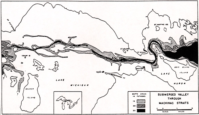
The name given to the lowstand in Lake
Huron honors Professor Stanley. Hough (1955) referred to this
channel in the Straits of Mackinac as the Mackinac River, but in keeping
with accepted principles of applying terminology to water-covered
topographic features, we refer to it as the Mackinac Channel. Note
that the channel even meanders, like modern rivers, around Mackinac
Island.
New bathymetry data has enabled scientists
to construct a more accurate map of the Mackinac Channel (shown
below). The map provides an integrated view of the Mackinac Channel
and the adjoining lakefloor topography. Channel depths of about 35m
occur NW of Waugoshance Point, and at a point north of Garden Island,
where the main channel crosses resistant bedrock.

Click here for
full size image (356 kb)
This material has been compiled for educational use only, and may not be reproduced without permission. One copy may be printed for personal use. Please contact Randall Schaetzl (soils@msu.edu) for more information or permissions.