Why was Monroe County not so heavily settled at this time? Primarily
because it was too swampy. The area along the shores of Lakes Erie and St. Clair and the
Detroit and St. Clair rivers that fell within the borders of Monroe, Wayne, Macomb, and
St. Clair counties was not as attractive to early settlers as the three inland counties of
Oakland, Washtenaw, and Lenawee. The soil in the shore counties varied greatly; some of it
was stiff clay, some was sandy. It was heavily timbered, unlike Oakland County in
particular, which received its name from the large number of "oak openings"
found within its borders (like the image below).

Click here for full size image (383 kb)
Source: Photograph by Randy Schaetzl, Professor of Geography - Michigan
State University
Nonetheless, the future prospects of the shore counties seemed bright, because they were
the entry point for most of the traffic coming in from the east. The founders of
the town of Monroe, named for President James Monroe, predicted a great future for the
town as the metropolis of the West. In addition, Mt. Clemens, the chief town in Macomb
County, Port Huron, Marine city, Algonac, and St. Clair all located in St. Clair County,
were other towns established in these early years that had some hopes, because of their
location along the busy waterway that formed the shoreline of this part of southeastern
Michigan, to compete with Detroit and Monroe as major ports.
Even though the Chicago Road had been opened before the Territorial
Road, the counties that were laid out along the Territorial Road, except for Van Buren,
contained a larger population in 1837 than those to the south along the Chicago Road. The
importance of the relative distance of a county from Detroit is shown by the fact that
each county in the second tier had a larger population than its neighbor immediately to
the west. In Washtenaw County, which was second only to its eastern neighbor, Wayne
County, in population, the towns of Ypsilanti, Ann Arbor, Saline, Dexter, and Manchester
had sprung up in the 1820s along the main roads, serving the surrounding rural areas. West
of Washtenaw, Jackson County was the most populous, its chief town, on the Territorial
Road, being called at first "Jacksonburg." The names chosen in both cases remind
us that the great advances in the settlement of Michigan’s interior regions occurred
during the administration of President Andrew Jackson (1829 to 1837).
A number of other southern Michigan counties, often referred to as the
"cabinet counties," were named after members of Jackson’s administration,
beginning with Calhoun County, to the west of Jackson County, named for Jackson’s
vice president, John Calhoun. Calhoun County and its neighbor on the west, Kalamazoo
County, were attractive to settlers because of the abundance of small, fertile prairie
lands. The early towns in these counties included Marshall, Battle Creek, and
Kalamazoo. Note the map below, which shows where the first land purchases
(cross-hatched areas) in Kalamazoo County were located--on prairies (yellow areas).
Check out this related page for more information.
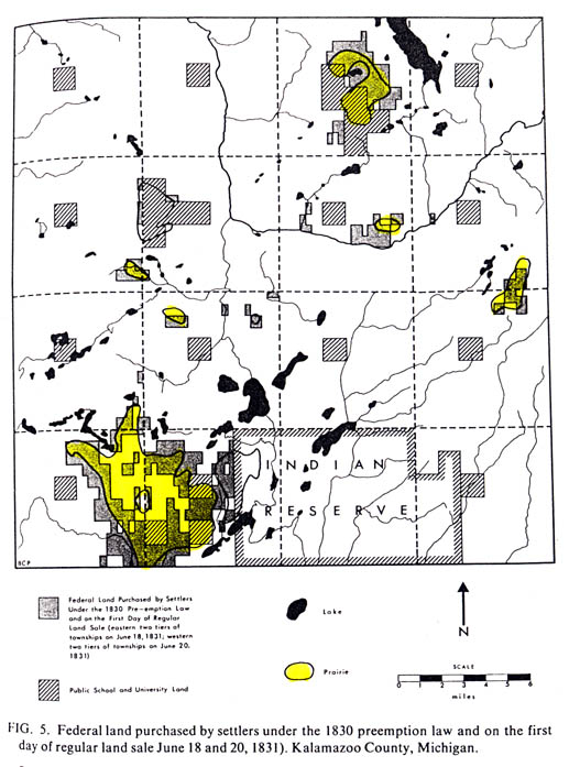
Source: Peters, B.C. 1970. Pioneer evaluation of the Kalamazoo County landscape. Michigan Academician 3(2): 15-25.
In the southernmost tier of counties many settlers entered overland
from the south; hence, distance from Detroit was less important in their development.
Hillsdale and Branch counties (the later named after Jackson’s secretary of the navy,
John Branch), lying west of Lenawee, were hilly and heavily wooded, factors that tended to
retard their growth. Jonesville, an important point on the Chicago Road, was the most
important town in Hillsdale County, while Coldwater was the chief settlement in Branch.
Lenawee County to the east was the most populous of the counties in this southern tier,
with Tecumseh and Adrian its principal towns. To the west, the second most populous county
was St. Joseph County, Branch County’s neighbor on the west, with White Pigeon,
Mottville, Constantine, Centreville, and Three Rivers being its principal towns. The St.
Joseph River, which wound through this county, was vital in promoting commerce during
these early years. St. Joseph County and its neighbor on the west, Cass, had several small
prairies which helped promote early settlement interest. Edwardsburg and Cassopolis were
Cass County’s chief towns, with the name of the town as well as that of the county
honoring Lewis Cass, governor of the territory. In Berrien county (name for Jackson’s
attorney general, John Berrien), the soils were sandy and its potential for fruit growing
was not recognized until later. St. Joseph was an important town because of its port.
Further south along Lake Michigan the name of New Buffalo is indicative of the soaring
ambitions of this town’s founders. Niles and Bertrand were the chief inland towns.
To the north of Berrien County along Lake Michigan lay Van Buren (after
the future president, Martin Van Buren, who also was Jackson’s secretary of state),
Allegan, and Ottawa counties. They were remote and their lands were less fertile,
particularly near Lake Michigan where sand drifted in for some distance. All three were
thinly settled in 1837.
The counties in the third tier west of Oakland had small populations at
this time. Although they contained fertile lands, they were distant from the main routes
of travel and lacked ready access to rivers from transportation. Livingston County was the
most thickly settled, with Howell and Brighton being its chief towns. Ingham, Eaton, and
Barry counties (named respectively after Jackson’s secretary of the treasury, Samuel
Ingham, secretary of war, John Eaton, and postmaster general, William Barry) had only a
few hundred inhabitants each. The fourth tier of counties was even more sparsely settled,
but towns of some size had grown up at Grand Rapids in Kent County, Ionia in Ionia County,
and Grand Haven in Ottawa County. Lapeer and Shiawassee counties in the eastern portion of
the fourth tier were in the Saginaw Valley and constituted a unit, along with Saginaw
County to the north, distinct from Clinton, Ionia, and Kent to the west. These last three
counties were settled in part by pioneers coming over the crude Grand River Trail, but
mainly by those moving northward from the Territorial Road.
The Saginaw River Valley contained lands that were densely forested,
with occasional oak openings. The soil was considered somewhat inferior by the early
settlers. Lumbering subsequently became a major industry in this region, but the earliest
settlers regarded the giant pines as a nuisance rather than a resource. Fur traders in the
area in some cases frowned on settlers, and because of the many marshes the Saginaw
Country was regarded as unhealthful. It chief advantage lay in its easy access by water.
Source: Michigan State University, Department of Geography
In the 1840's, Michigan had a mining frontier of enduring importance to the
state and the nation, a fact that goes unmentioned in most of the histories of the
American West, though they deal at length with the mining rushes in the Far West. Yet the copper taken from Michigan mines, and the iron
ore produced in Michigan and across the state border in Wisconsin and Minnesota have
been of far greater importance in the building of the nation than the gold and silver
which came from the mining bonanzas of California, Nevada, and Colorado. A report made in
1841 by Douglass Houghton, the state geologist, was followed by a rush of prospectors to
the Copper Country of Michigan's Upper Peninsula and the establishment of mining camps
which had many of the characteristics of those a few years later in California. The
discovery of nuggets of silver with the copper added to the excitement. In 1844, iron was
discovered in another part of the Upper Peninsula and soon that ore, too, was being mined.
Michigan led the nation in copper production from 1847 until 1887, and in the production
or iron, Michigan ranked first until 1900. Of major importance in making the vast
quantities or ore in Upper Michigan accessible was the construction of locks and a canal
at Sault Ste. Marie.
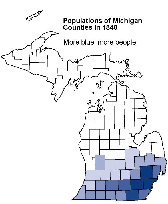
Note (in the map below) that, by 1850, the "settlement frontier" had moved west.
While people were still settling in Michigan and buying up land there, most of the
land had by then been purchased.
Source:
Unknown
By 1860 Michigan was a democratic community of farmers, artisans, and
lumbermen. It was derived mainly from New England, New York, Pennsylvania, and Ohio, with
some immigrants from Canada, Great Britain, Ireland, Germany, and Scandinavia. Its
industries were largely those of the home and the small shop. Crude copper and iron mining
had begun in the Upper Peninsula, Detroit had become a center of iron manufacturing, and
lumbering was well on its way to the peak it touched in the 1880's. A new canal around the
Sault started the heavy stream of shipping that has made Michigan one of the Nation’s
great marine States. But the Straits in 1850-70 was still a remote region, where Indians
loitered in the street and the mail was carried in winter by dog sled.
The mining frontier added a new dimension to Michigan's
population. The dominance of New England stock, so marked in the settlement of the
farmer's frontier of southern Michigan, was notably absent in the mining country, although
Boston dollars were heavily invested in the copper mines. The newcomers included at first
workmen from the lead mines of Illinois and Missouri. Heavy reliance was placed, over the
years, on foreign immigrants. The contributions of skilled miners from Cornwall were of
inestimable value. There was a large influx of Finns. Many Irish,
Germans, and -after 1890-Italians, and other southern Europeans came.
The Early Michiganians
What sort of people were these early Michigan settlers? In many
respects they shared the characteristics of the American frontier people wherever they
were found. They were eager to better their lot in life and sought more abundant
opportunity for themselves and their children. Those who were well-to-do and comfortable
in the East were less likely to become pioneers in the raw western country. But one should
not consider the westward-moving pioneers the scum of the eastern states. Many men, no
matter how poor their condition, preferred to accept things as they were, lacking the
energy and ambition to better their lot. Such persons did not go west. Those who left for
the hardships of frontier life were those with abundant vitality, the will to get ahead in
life, and enough resources to obtain the essential supplies for the journey. They were
neither the very rich nor the very poor. They were usually young and were looking ahead to
the future, not so much living in the present as in their dreams of what the years ahead
might bring.
They abounded in self-confidence and in many cases were rugged
individualists. Individualism frequently went to the point of eccentricity. But it was
blended with neighborliness, hospitality, and a large measure of tolerance. The pioneer
had to be versatile enough to subsist with little dependence on the outside world. Most of
these people were farmers in the East. Factory workers did not possess, as a rule, the
financial means to move west; furthermore, they lacked the skills and experience demanded
of farmers.
In all these traits the Michigan pioneers resembled their counterparts
elsewhere in the American West. But in some respects they were distinctive. First and
foremost was the fact that they were predominantly New Englanders or sprang from New
England stock. The largest numbers came from western New York, but were largely the
descendants of Yankees who had settled in this region after the American Revolution.
Nowhere in the West did the Yankee stock predominate to the degree that it did in
Michigan. The influence of this dominant New England element on the history of Michigan
has been profound.
Once in the state, the pioneers secured a wagon, if they had not
brought one along, as well as necessary supplies for the subsistence of their families
until they cleared and cultivated their land. The successful pioneers had to be keen
judges of the quality of the land, and to some extent the pioneer was attracted to the
kind of land he was accustomed to cultivating. They did not like stony soil, for obvious
reasons. Good drainage was important, and the settler avoided swampy, marshy land in part
because it was regarded as "unhealthy" (i.e., mosquitoes!). Land was called
"heavy" if its clay content was high, or "light" if it was sandy. To a
considerable degree the soil was judged by the kind of trees that grew on it. The best
soils were supposed to lie under a covering of black walnut, ash, and sugar maple. Bur
oaks denoted good land, too, but land on which pine grew was generally sandy and
infertile.
Before deciding specifically where to settle, the pioneer
considered many factors, including the quality of the soil. Proximity to the main roads
and the larger rivers was an advantage because it facilitated the bringing in of supplies
and the marketing of products. Particular care was used to seek a location that was
regarded as healthful. An abundant water supply was essential. Finally, locations were
naturally preferred as close as possible to the point of entry---in most cases, Detroit.
Some of the text and images on this page weres adapted from Dunbar and May's Michigan A History of the Wolverine State, C.M. Davis’ "Readings in the Geography of Michigan" (Ann Arbor Publishers).
This material has been compiled for educational use only, and may not be reproduced without permission. One copy may be printed for personal use. Please contact Randall Schaetzl (soils@msu.edu) for more information or permissions.