As we examine the methodical and sometimes discontinuous way that the ice margin retreated from Michigan, we must keep in mind that the main lines of evidence we have for this story come from the end moraines left behind AT those margins.
Probably the first lobe to really begin
its retreat was the Saginaw lobe. The Saginaw lobe was thinner than
the Lake Michigan and Erie lobes and therefore melted faster and was the
first to begin its retreat. Its first halt after uncovering an area of
four or five townships in St. Joseph and Cass counties was near Sturgis,
where it built the first and oldest moraine in Michigan --- a line of
hills passing through Sturgis and bordering the triangular area first
uncovered. This hilly ridge has been named the Sturgis moraine. From this
outpost the lobe receded step by step into the Saginaw Valley, and at each
halt built a moraine, so that its retreat across Michigan is marked by a
succession of more or less parallel moraines closing in on Saginaw Bay
from the south, with their ends tied to the massive moraines of the Erie
lobe in the east and the Lake Michigan lobe in the
west.
After its brief stop at Sturgis, rapid melting
caused the Saginaw lobe to retreat to the position of Tekonsha where it
built the slender Tekonsha moraine. Further retreat brought the Saginaw
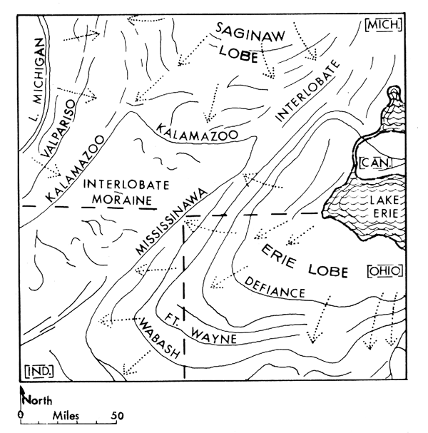
ice front to the position of the large and wide Kalamazoo moraine about
14,800 years ago. Here it halted long enough to build up a high, wide,
massive, very hilly range. The Kalamazoo moraine extends from Hastings
south and east through Marshall to Devil�s Lake in Lenawee County where it
connects with Mississinawa moraine which outlines the outermost position
of the Erie lobe in southern Michigan. On the west the Kalamazoo moraine
of the Saginaw lobe unites with the moraine also called Kalamazoo, which
the Michigan lobe was making at that time, extending from Hastings through
Kalamazoo and Cassopolis. This Outer Ridge of the Kalamazoo moraine marks
the most easterly extent of the Lake Michigan lobe. From this time the
pattern of moraines records the retreats and halts of all the glacial
lobes --- Erie, Huron, to the east, Lake Michigan in the west, and the
Saginaw lobe between, and the Superior lobe in the north.
Renewed melting of the Saginaw lobe caused its front to recede to the
vicinity of Charlotte where it built the Charlotte moraine. This ridge may
be traced to the vicinity of Grand Rapids where it ties in with another
morainic system of the Lake Michigan lobe --- the large and wide
Valparaiso moraine, which comes north from Indiana. 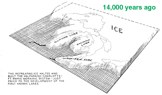
The Michigan
lobe had retreated from the position of the Kalamazoo moraine to make a
long stand in the west, during which it built up the high Valparaiso
moraine which marks the border of the Lake Michigan lobe from Indiana to
central Wexford County. This moraine is a typical "knob and kettle"
formation. The highways of the region lead from valley up over knobby hill
or high steep knoll, from whose summit one may look over a bumpy country
of hill and kettle-like basin filled with lake or swamp or drained to
rich, dark mucks.
Retreating from the Valparaiso
moraine, the Lake Michigan lobe halted long enough before it retreated
into the Lake Michigan basin to build the Lake Border morainic system at
13,300 years ago, a complex of low ridges which closely follows the margin
of Lake Michigan. Meanwhile, the ice over the eastern part of the State
was building the massive West Branch and Gladwin moraines north of the
Grand River. But south of the river the rapidly retreating Saginaw lobe
was building only slender moraines which fray out from the West
Branch-Gladwin moraine and mark the halts of the Saginaw lobe as it
back-stepped into the bay. This group of slender moraines does not have
the rugged topography of the moraines to which they are tied at either
end, because the Saginaw lobe was thinner and had cleaner ice than did the
other lobes. Named in order of development from the vicinity of Lansing
northward, the thin, low moraines of the Saginaw lobe are: Lansing
(viewable from the intersection of Farm Lane and Mt Hope, just look due
south at the rise of hills on the horizon), Grand Ledge, Ionia, Portland,
Lyons, Fowler-St. Johns, Flint and Owosso.
After the
next retreat the Lake Michigan-Saginaw-Huron lobes then readvanced back
into the state. This readvance was a large one, and occurred over the
entire Great Lakes region; it is called the Port Huron advance and it
constructed the Port Huron moraine. 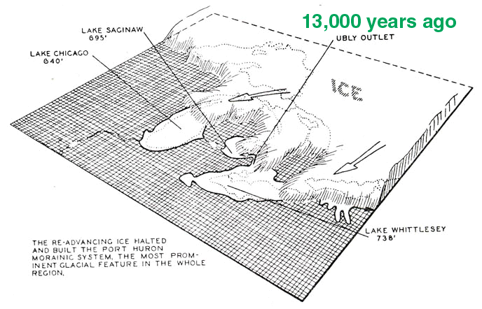
The same
determined stand was taken along the entire glacier front from east to
west, so that this moraine has been traced more precisely than any other
and stretches from the Genesee Valley in New York to Lake Michigan north
of Ludington. This advance took place at about 13,000 - 12,000 years
BP.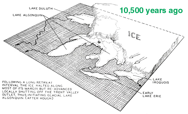
The glacial features of the UP were
formed in large part by the Superior lobe of the glacier. This mass of ice
was directed into the Superior Basin from the northeast, and pushing out
over the rim of the basin; it covered the greater portion of the Northern
Peninsula. The Superior lobe also left end moraines, and in the western
part of the peninsula complicated the pre-glacial rugged topography by
filling some of the gorges with drift, diverting the courses of some
streams and damming others by building morainic dams across their courses.
Lake Gogebic lies in the channel of a stream that once flowed to the north
but its headwaters were cut off, dammed by a moraine, and Lake Gogebic
formed.
This material has been compiled for educational use only, and may not be reproduced without permission. One copy may be printed for personal use. Please contact Randall Schaetzl (soils@msu.edu) for more information or permissions.