SOUTH MANITOU ISLAND
When one thinks of the most influential islands of Michigan, what comes to mind? I would assume that Mackinac Island may be on at the top of the list. However, South Manitou Island should be on that list as well. Many people don�t know much about the history of this island and have no idea its impact it has had on Michigan and its waters. Here is the story of this great island that doesn�t get the recognition it should.
Legends
You cannot talk about the history of South Manitou Island without talking about the Chippewa Indians legend of Sleeping Bear Dunes. As the classic Indian legend states, there was a mother bear with two young cubs on the Wisconsin side of Lake Michigan. When a fire broke out on land, they had no where to go but flee from the fire by swimming to the other side of Lake Michigan. The mother made it to the shore but only to look back and find her two cubs missing. The two cubs were too exhausted to make it to shore and drowned in the choppy water. The mother bear stuck close to shore in hopes that her cubs would appear. While the mother bear slept, the Great Manitou rose the two cubs up and today that landmark is known as North Manitou Island and South Manitou Island. The mother bear remained by the shoreline and today is known as Sleeping Bear Dunes.
A much less popular legend of the islands is the Indian legend of the seven Indian warriors. The legend is to explain why the islands were not populated by the Indians. According to the legend, a tribe from the Upper Peninsula came and fought a tribe in the Lower Peninsula. Only seven warriors survived the battle from the Lower Peninsula and when the victors celebrated on the islands. During the night, the seven warriors attacked the sleeping tribe and wiped out the camp. It was a mystery as to who was behind the attack and so it was blamed on evil spirits. Because of this legend, people would not populate the island for fear that they would be attacked by the evil spirits as well.
What Really Happened?
Although the legends are interesting in themselves, in reality, the islands were artistically carved out by the glaciers. Around 10.000 years ago, glaciers covered the upper part of the Lower Michigan. When the glaciers retreated, they carved out the Great Lakes. Today, the islands are separated not only from each other, but also from the mainland. You can see the layout of the islands compared to the mainland in figure 1. This picture shows where the islands are compared to Sleeping Bear Dunes which is in Leelanau County. As you can see, the North Manitou Island is much bigger in size than South Manitou Island. Similarly, the two islands can only be reached by a ferry which travels from Leland to the islands and back.
The Founders
Although South Manitou Island is small in size compared to North Manitou Island, the island has many good qualities about it that makes this island unique compared to all other island in Michigan. To begin with, it is important to talk about the history of its inhabitance. Although there were Indians in Michigan before the white man arrived, the white man was the first to inhabit the island. �They remained virgin territory covered with thick primeval forests of pine, cedar and hemlock until the white man came.� (Vent 8) There is no certain date with which history can place on the inhabitance of this island. As history tells us, Nicolet discovered Lake Michigan in 1634 and it is thought that a French trader or missionary discovered the island first. The islands were noted on a map in 1673 by Joliet. However, more than 150 years would pass before people would leave a mark on the island. It was because of the revolutionary steam boat invention that lead people to the island. �We stopped at the Manitou�s to refuel,� said one sailor who was the first to acknowledge his visit to the island (Vent 10).
The first to be acknowledged to have visited the island is Henry Rowe Schoolcraft (figure 2). He was intrigued by the Chippewa Indians that inhabited the coast of Lake Michigan. While traveling down the coastline, he recorded a description of the area.
We embarked at daylight. In going thirteen miles we passed a small stream called Platte River; and nine miles beyond reached a noted point on the east shore of the lake called the Sleeping Bear. The shore of the lake here consists of a bank of sand probably 200 feet high, and extending eight or nine miles without vegetation, except a small hillock about the center which is covered with pines and poplars, and has served to give name to the place, from a rude resemblance it has when viewed at a distance, to a couchant bear. There are two islands off this part of the coast in plain view from the shore, which are called the Sleeping Bear Islands. (Vent 11)
Along with his vivid descriptions, he took a liking to the Indians and recorded many of their legends. It is thanks to Schoolcraft that we have documentation of these legends. He favored the Indians so much that he married the chief�s granddaughter.
First Settlement
It wasn�t until 1856, a full 183 years after the island was mapped, the Hutzler family settled on South Manitou Island. After the Hutzler family traveled to America from Europe, George Hutzler took a job on the steam boat Iowa. Iowa traveled through the great lakes and made passages from Buffalo to Chicago regularly. Hutzler was constantly looking for a place for his family to settle. He was not impressed with the busy streets of Chicago and was worried because he thought that it was built on a swamp and pictured it to be unhealthy for his family. He did not want to take the risk of disease since his family had just recovered from cholera. When the Iowa stopped at South Manitou Island to load up on wood, Hutzler noticed its beautiful surroundings and pictured his family there. In the winter of 1856, it is said that the Hutzler family spend their first Christmas on the island. Soon enough, the family settled on the island with a wooden cabin, a barn, and a successful farm. As shown in figure 3, the Hutzler barn stood until the 1930s until it was stuck by lightening.
Although the Hutzler family was the first to build on the land, the first official settlers that were entitled land was the Burton family. In 1849, W.N. Burton purchased 50 acres of land on South Manitou Island. No one knows exactly when the Burton family arrived on the island but it is documented that William Burton was the first keeper of the lighthouse.
The Lighthouse
The island began to be a successful port for boats passing by. A lighthouse was erected in 1840. Congress helped with the funds to build the lighthouse and it turned out to be the most beautiful and successful lighthouse on the Great Lakes. The lighthouse was used to guide vessels around the shallow waters with its beaming light. Due to the treacherous waters around the island, the lighthouse prevented many shipwrecks as well. Prior to the construction of the lighthouse, there were many shipwrecks around the island and therefore the lighthouse was a welcomed addition. William Burton was the first keeper of the lighthouse but after his inability to keep good care of the lighthouse and his duties, Bael Ward was elected keeper of the lighthouse under specific conditions. He had to live within the lighthouse and keep to his regular duties.
�Lighthouse keepers were expected to keep everything shining and spotless. Each morning the keeper washed and shined his lamp chimneys, trimmed the wicks, filled his lamps, rubbed the lens with a chamois skin, wound up his clockwork, and looked around the walls of the lantern room to see whether they were in need of washing or a new coat of gleaming white paint� (Vent 50).
The lighthouse was closed down on December 12, 1958 and all staff members were forced to find other employment. You can find two pictures of the lighthouse on South Manitou Island in figure 4.
Coast Guard
The Coast Guard Station on South Manitou Island became an essential part of the care of the waters of Lake Michigan. The station was originally a Life-Saving Service center until 1915 when it became the United States Coast Guard Station. This station was to be used to help vessels in distress and to help take inventory of equipment and supplies. The station opened with only a six man crew which was under the management of Gus B. Lofberg. Daily, the station would take descriptive notes as to the happenings among the island and its shoreline. An example of one of these documents is shown in figure 5.
�In addition to making reports similar to the preceding one, Lofberg was expected to record daily the number and types of vessels that passed the station, the direction and velocity of the wind at stated hours, the general nature of the weather, and variations in temperature� (Vent 63)
Because of these types of documentation, Michigan has a good record of the early happenings on South Manitou Island. The description and vivid depictions allow historians to understand a little bit about the past. In figure 6 you will find pictures of the Coast Guard crew of 1928. These men had to endure some of the worst weather conditions. It was a brutal job but these men, along with countless others, saved many lives and kept the island in good condition.
Vegetation and Animals
The island was much like the mainland when it comes to vegetation. However, one unique aspect of the island was the growth of white spruce. Along with a thick forest in the interior, the coast line was lined with dunes and bluffs. The island was a place not only for steamers to stop for a safe harbor to refuel, but it was also a place to restock on wood.
�According to figures released by the American Forestry Association, South Manitou is the location of three of the nation�s largest trees in their species�The trees have been called champions of their kind� (Vent 82).
However, much of the original trees of the island were cleared for farming or used for wood for the steam boats.
When it comes to wildlife, there were fewer varieties than on the mainland. This is to be expected with the remoteness and the lack of space. Species like the American toad, painted turtles, several types of birds, fox squirrel, and the muskrat to name a few. Due to the thick coverage of trees, there was an extensive variety of birds.
Conclusion
As one can tell, South Manitou Island has a more extensive history than one might think. Today, the island is state owned and used as a tourist location. Campgrounds scatter the land and remnants of the first settlements are recognizable. The one room school house stands along with the documentations from the lighthouse and Coast Guard stations. At one time, this island was a running city for travelers of the lake. The island may be small in size but it is obvious that it had a great impact to Lake Michigan waters and the people that traveled them.
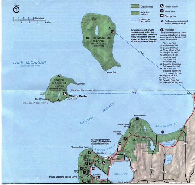
This is a map of the surrounding area around South Manitou Island. It sits off the coast of the western side of the Lower Peninsula and is northwest of Sleeping Bear Dunes. The only way to reach the island is by boat and a ferry travels from Leland to both islands.
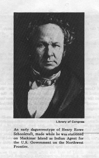
The late Henry Rowe Schoolcraft is acknowledged to be the first visitor of South Manitou Island. He encountered the Chippewa Indians upon his arrival and became friends with them. Schoolcraft documented his trip and recorded many of the legends that we know today.
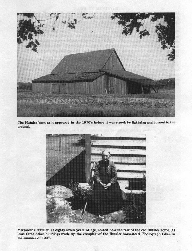
The Hutzler barn was one of the very first structures build on South Manitou Island. The Hutzler family was the first settlers on the island. Margaretha Hutzler, married to George Johann Hutzler, were the first couple to live on the island.
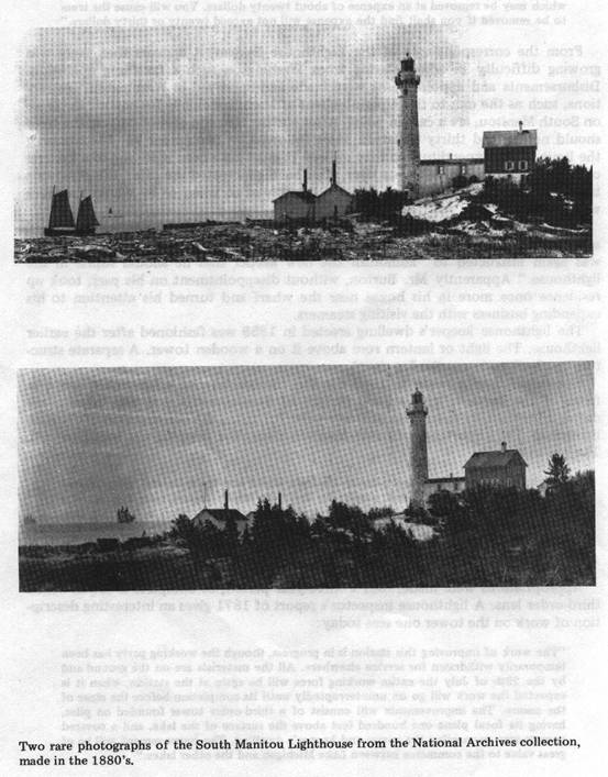
This lighthouse has not only proven to add to the beautiful landscape of South Manitou Island but it has served as a useful mechanism to keep its harbor safe. The lighthouse has added in the decrease of shipwrecks around the shallow waters around the island and has been a guiding light through the treacherous waters in times of storm.
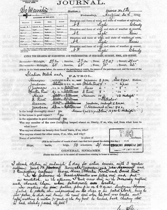
This is an example of the types of records the Coast Guard used to keep to document daily happenings on and around the island. The detailed descriptions on these records have served as an important document for the island to understand the islands past.
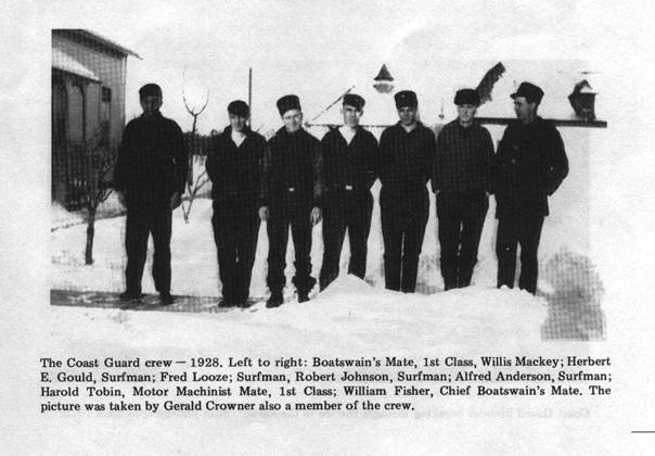
This is a photograph of the 1928 Coast Guard crew. These men were said to be some of the bravest men on the island. They had to fight the cold winters and the dangerous waters around the island.
REFERENCE
Vent, Myron H. South Manitou Island. Springfield, VA: The Goodway Press, Inc., 1973.
Page created by Katherine Rich, a GEO 333 student
This material has been compiled for educational use only, and may not be reproduced without permission. One copy may be printed for personal use. Please contact Randall Schaetzl (soils@msu.edu) for more information or permissions.