GEO 333: Geography of Michigan and the Great Lakes Region
INTERACTIVE MAPS
...to help learn Michigan's Counties
VERSION 1
VERSION 2
VERSION 3 (a fun one)
VERSION 4
A good one from the internet: project..purposegames.com/game/michigan-counties-quiz
...to help learn Michigan's major cities in the UP,
click here
...to help learn Michigan's major cities in the lower peninsula, click here
...to help learn Michigan's major bays, click here
...to help learn Michigan's major islands, click here
...to help learn Michigan's major lakes of the UP, click here
...to help learn Michigan's major rivers of the UP, click here...to help learn Michigan's major lakes of the lower peninsula,
click here
...to help learn Michigan's major rivers of the lower peninsula,
click here
...to help learn Michigan's major landforms and landform regions, click here
This page has some maps on it with the counties already labeled.
This link sends you to a map that shows most of the materials you need to know for Quiz #2.
Here is a useful link that shows some (not all) of the rivers that you need
to know for Quiz 2:
http://geology.com/state-map/maps/michigan-rivers-map.gif
Open this file and click on a county to learn its name: Counties map
Open this file to see many of the items/places/features you need to know for Quiz 2: Quiz 2 stuff
On this page there are interactive quizzes for all of the materials on Quiz 2: project..purposegames.com/profile/391890#
Here is a Powerpoint file that shows some hand-drawn maps (by a student) that could be useful for Quiz 2. Link
LIKE TO PLAY COMPUTER GAMES? Here's some games you can play to learn Michigan place names better!
Rivers of the Lower Peninsula - here
Rivers of the Upper Peninsula - here
Cities of the Lower Peninsula - here
Cities of the Upper Peninsula - here
Counties - here
Lakes, Bays and Straits - here
Islands etc - here
Help study for Quiz 2 by using this quizlet site! Here
Here's another game to help you learn the materials for Quiz 2. Have fun!
STATIC AND PRINTABLE MAPS
For each of the blank (outline) maps below, load the page, then print
as many copies of it as you need. For note-taking purposes, try to
have several "on hand" at all times. You'll be glad you did!
FOUR small, blank maps of Michigan: print directly
WORD document with the
map in it
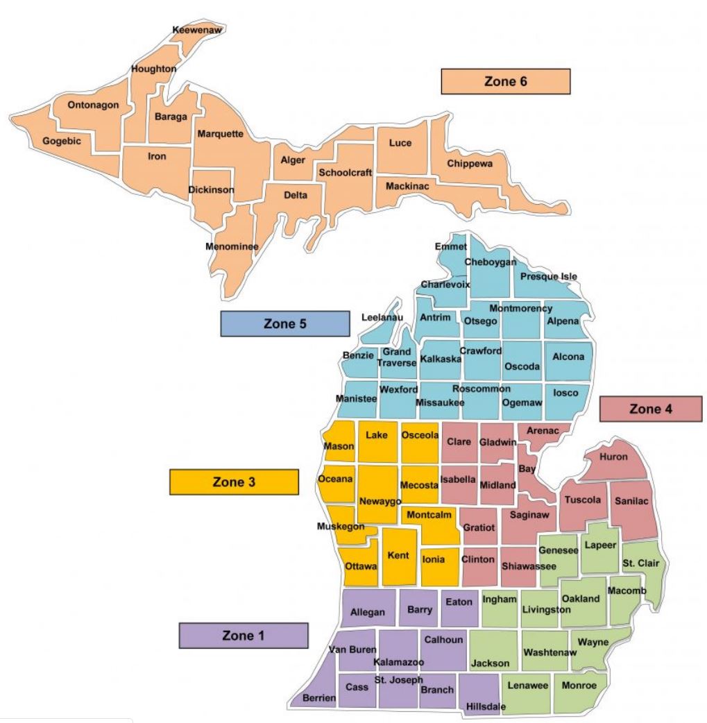
Michigan county map
County outline
map of Michigan: print directly
WORD document with the map in it
Regional (Great Lakes) map with state names:
print directly WORD
document with the map in it
Regional (Great lakes) map with
county outlines: print directly WORD document with the map in it
Another regional map w county outlines, but
this one covers more of the western Gr Lakes:print directly
WORD document with the map in it
Outline map of the United States
Another outline map of the USA
Four small outline maps of the USA
Outline map of North America
Map: North Pole to Mexico
Moraine map
PDF of the Moraine
Map (168Kb)
1907 Map of Michigan
Counties
Printable WORD document of the
OLD Michigan Paleozoic
rock column
Printable
WORD document of the OLD Michigan Paleozoic rock column (split into two separate
halves)
Original
jpeg image of the OLD Michigan Paleozoic rock column (1.7MB)
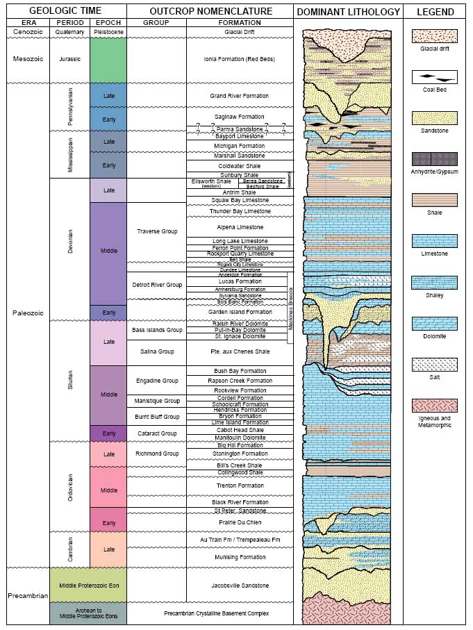
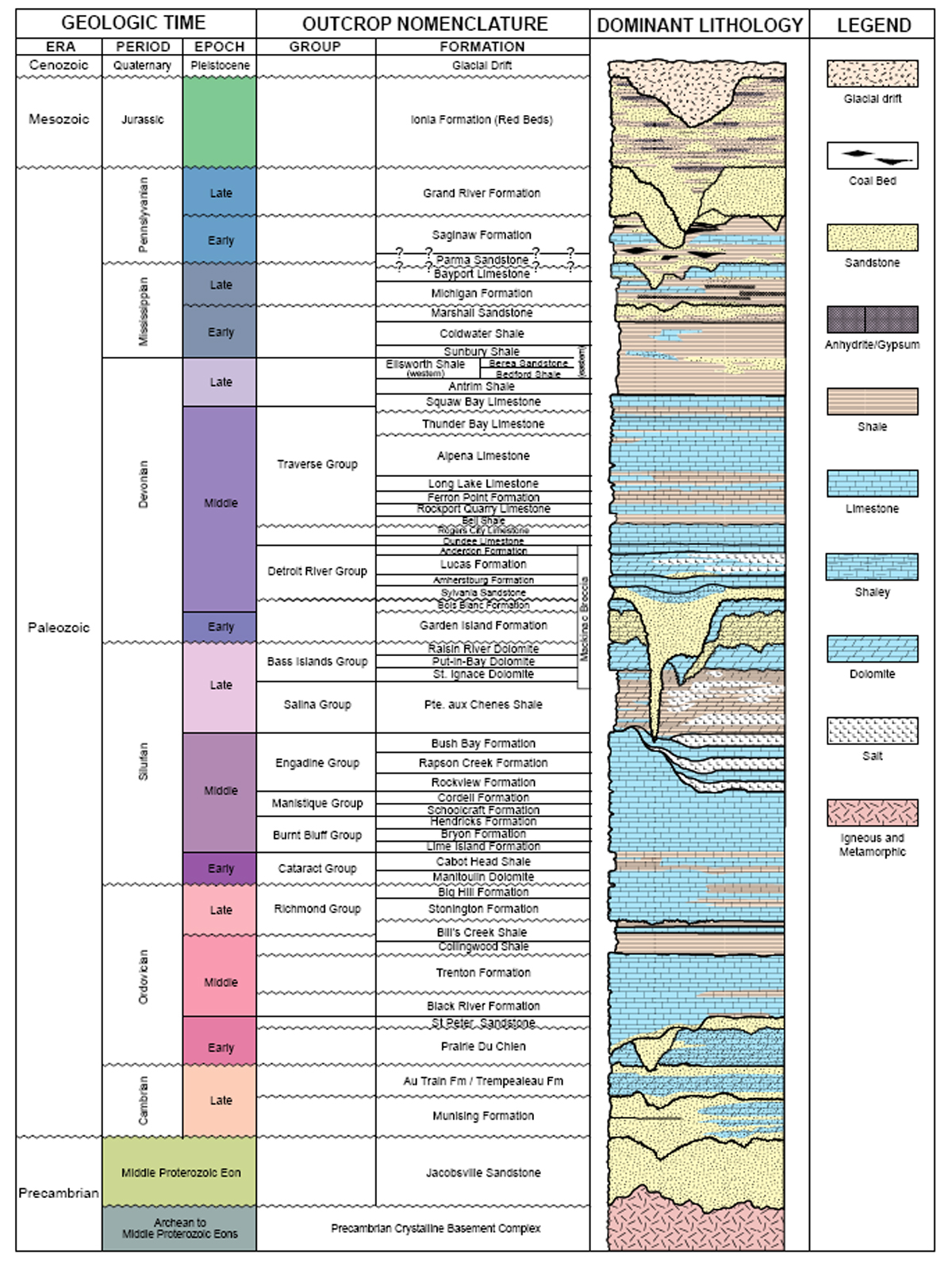
Images of the new (2007) Michigan Paleozoic rock column
Entire column, low resolution
Entire column, high resolution
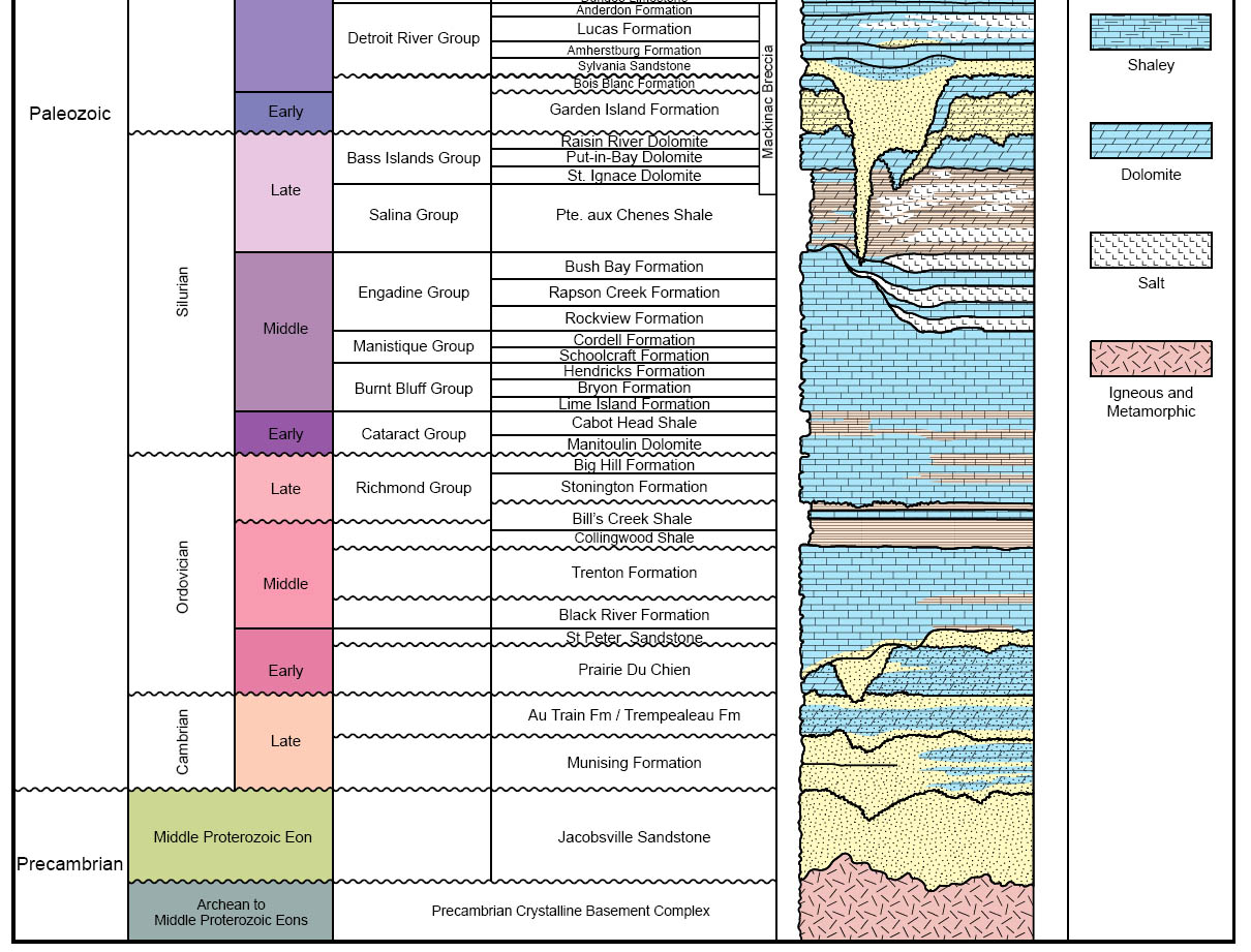
Upper half of the column
Lower half of the column
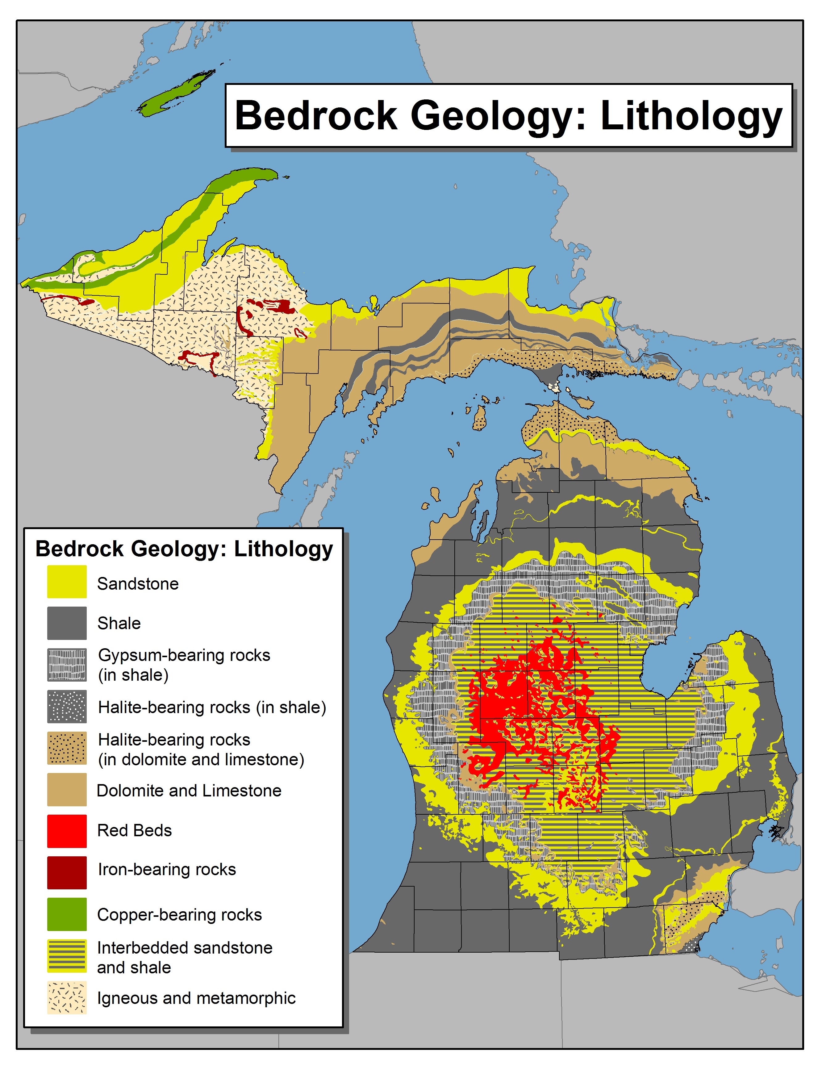
Bedrock geology maps of Michigan
Lithology
Rock age - lower peninsula
Rock age - upper peninsula
Interactive map of the ranges for some of Michigan's major tree species
Interactive map of Michigan's ecoregions
A map of Michigan's landforms and landform regions, very detailed: here
This material has been compiled for educational use only, and
may not be reproduced without permission. One copy may be printed for personal
use. Please contact Randall Schaetzl (soils@msu.edu)
for more information or permissions.